The last couple of days have been okay for storms, although the moisture has been a little more sparse than preferable for good storms. Today, though, is somewhat different. And that's why I'm writing.
Moisture - dewpoints in the high teens north to low 20s south. (North-south today is a huge area--look at the tornado risk map.)

The lift is good along the advancing cold front, the shear is plentiful with 500 mb winds at or above 50 knots, and instability is strong, too--3000 J/kg.
All this is good stuff, and good for storms.
But.
I don't like it.
Well, maybe I shouldn't be so glib; I don't like this kind of setup, although given the choice between chasing this setup and not chasing at all I'd pick chasing. Of course.
The setup today has the shear oriented almost parallel to the forcing mechanism, so any storm that forms has a higher than usual chance of having its inflow polluted by another storm upstream from it. As well, the isobaric surface flow is southwesterly as opposed to southerly or even southeasterly. (This can be fixed by approaching short-wave troughs dropping surface pressures and the winds backing in response.) And lastly, because of the environmental wind speeds involved, storms in this environment are usually flying along--too quickly to chase.
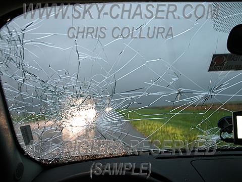
Justin and I have been having some conversations offline about this chasing thing and our forecasts; we have both entered a virtual chasing contest and submit our forecasts for it. The thing is, though, that the virtual chase is just not real enough that the strategy for winning the contest isn't the same as the strategy for chasing in real life; for the contest you want to catch as many severe reports as possible within a certain radius of your location. In real life (at least for me; Justin can speak for himself) I like to be just south of a storm, watching its inflow and the entire growth of the updrafts and how the whole thing works together. I very rarely (I almost typed "never") want to get into hail from a supercell. Here's why.
The last couple of days have been rather busy at work for me and, I assume, Justin; expect this from time to time so posting may sometimes get inexplicably light.
By the way, my target as described here a couple of days ago hasn't changed much; for picturesque and slower storms today I like tail-end Charlie, near Tyler, TX--close to the 12 bull's eye of the SCP in the following map.

I chose St. Louis, Missouri for today...but I'd now want to be somewhere in NE Arkansas...which leads me to another reason that should be on one of Dave's 'I Don't Like It' notes...the chase conditions. Arkansas has 'some' flat areas where visibility is great...but for the most part it is terrible. Trees are tall...roads curve here and there, go up and down...and there's snakes!
ReplyDeleteWho knew that Dixie Alley this year would be producing more then Tornado Alley!
Tomorrow I am liking NC Louisiana for another potential Yazoo City wedge day! Hopefully with no fatalities.
Dave, nice pic by the way of the Yazoo City monster by Dick..haha